Saturday, December 17, 2016

Grooming Report - Summit Prairie 12/17/16


from glen johnston:

Bill Prophet took Cat 1 from Huddleston to the lower lot at Summit Prairie, SW on FR 16, SW and south on FR 1651 (Summit Cr), east on FR 1410 (Wickiup Cr) to FR 14, north to FR 16 and Summit Prairie, east on FR 1660, north on FR 650 and FR 598 back to start.  Bill reports good snow and grooming well;-)

Thursday, December 15, 2016

FR 16 Summit Prairie 12/15/16 Backwards Day


click on image for larger version. you can save the larger version as a .png file to your computer open and be able to zoom in for more detail.

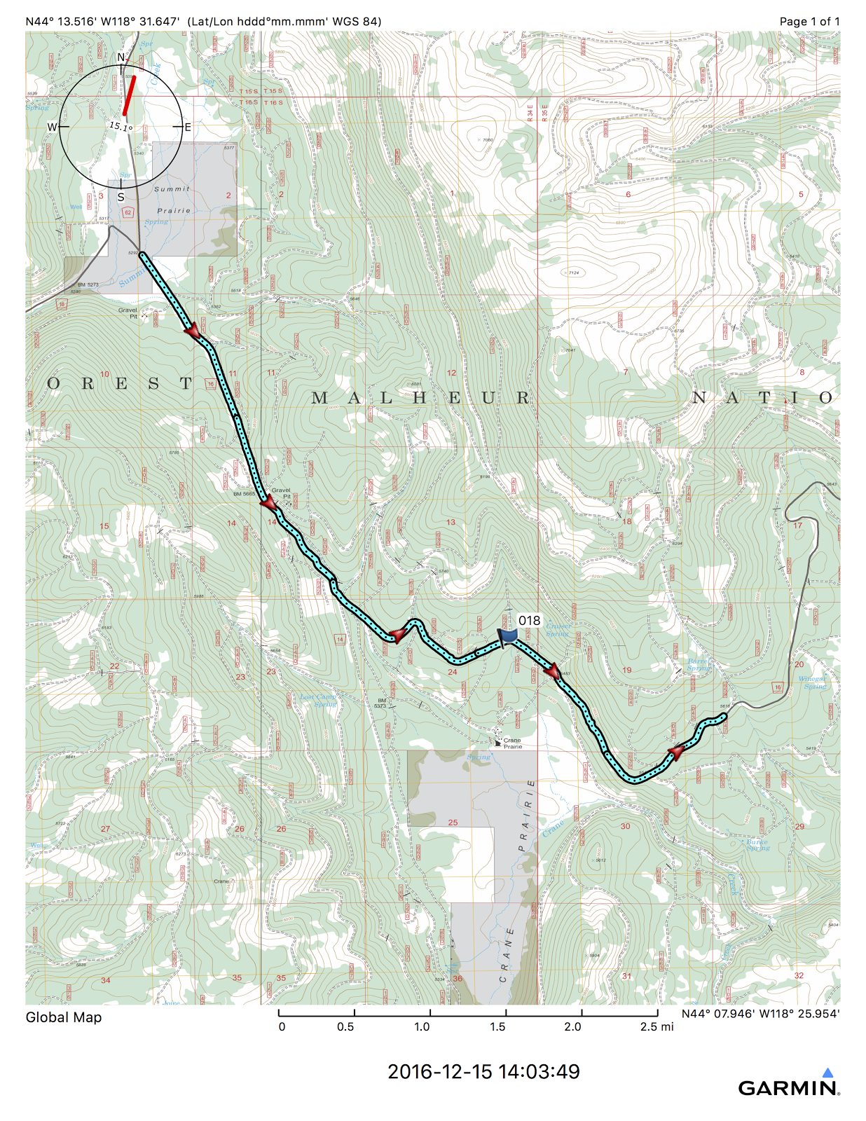
Location: Co 62 to Summit Prairie.  FR 16 south

Road & Trail Conditions: Hwy 26 plowed, packed, blowing sno, worse at curves east of JD. co 62 being plowed as i drove up:


gratitude to the grant county road dept for keeping the 62 rd open:


FR 16 not plowed west of summit prairie. sounds like it won't be unless logging extends east from FR 15, Parish cabin jct.

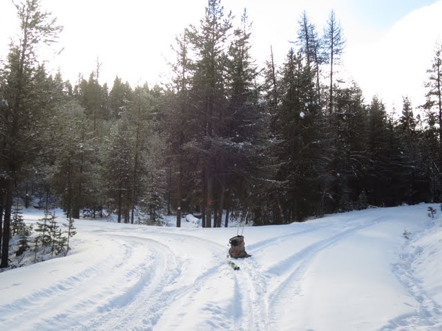
Snow Conditions: First grooming yesterday. 18+" base with 1-3" new powder since.  moist.

Skis on & temperature:  11am 34° (JD 22°)

Skis off & temperature: 4:30pm 29°(PC & JD 24°)

Distance: 12+ miles;

Rating (1-10; 10 awesome): 9.5 (-.5 for sticky sno in dec.)

Comments: this is backwards day.  colder in the valley than the summit.  more sno overnite at starr ridge than huddleston, sticky sno in dec., less sno further east you go on 16.  it is useful to be flexible.

saw a number of insects flying & on the sno.   they'll need some warm coats.  fri nite forecast for summit prairie: Mostly clear, with a low around -16. Wind chill values as low as -31

just groomed yesterday, still 2-3" powder overnite made for some breaking of trail.  something very satisfying about skiing back on the trail you broke.


noon:30 stopped for snack & maxiglide wax on skis; resolved sticking sno

i like this trip for conditioning.  first 1.5 miles has gradual 600' elevation climb.  after that, moderate slopes.  i love the 16 rd as it heads east above crane prairie. would like to extend conditioning & mileage (+9) to get to little crane campground (& back).


ice crystal diamonds falling out of black sky on slow drive down co 62
 i love this place

Grooming Report - Huddleston/Summit Prairie 12/14/16

click on image for larger version you can save the larger version as a .png file to your computer open and be able to zoom in for more detail.


 > HOORAY!!! Grooming started today.  Here is operator Dave Hannibal's report;-)

> Grooming report
> Cat one out of Huddleston for 47 miles in 10.2 hours.
> 1665 to 625 to1660 to 478 back on the 1665 down to 16 then out to Short creek and back on 16  to summit prairie, dressed up lower lot and 135 to upper and around Huddleston lot but not the loop.  14ish down trees moved and all cattle gaurds filled on route.
>  Real nice snow,  had to run lockers more than a few times up high as its deep.
> Cat running good, light snow all day and a great start on the season!
> Dave
>

Sunday, December 11, 2016

Snowshoe Trail - Bear Valley 12/11/16


click on image for larger version
 you can save the larger version as a .png file to your computer open and be able to zoom in for more detail.


Location: Hwy 395 south to Co. 63 west 12+ miles

Road & Trail Conditions: 395 plowed with icy patches, Co 63 plowed & packed; FR 4920 from starr ridge campground has several ski tracks & sno looks good

Snow Conditions: 12" powder starting to form base, continued sno thruout day,

Skis on & temperature:  9:30am 29°

Skis off & temperature: 12:30pm  29°

Distance: 6 miles

Rating (1-10; 10 awesome): 10+

Comments: allen taylor & i ventured out to the first run on his favorite trail in bear valley.

alternating blue skies:


and moderate sno. there is one hill in the first mile, 100 yds, a little steep, with todays deeper sno required some herring bone technique.


not too long, good conditioning, the remainder of trail basically flat to slight downhill:


we finished the loop going from fr31 to 63 & back to 014 as last section is not well marked & requires stream crossings.  will map this out in detail later.

there is also a side road, 650 at the highest point that leads out to a lovely lookout east toward south fork john day. passed on this today, too cloudy.

can access this trail from Co. 63 & fr 014 jct (easier to see fr 594 up to flagtail mtn. on other side of road) or down fr 31. easier to climb the elevation from 014.

there are some lovely aspen & pine stands along the creeks on the east side:


Starr Ridge Sno Park - FR 333 12/8/16

click on image for larger version you can save the larger version as a .png file to your computer open and be able to zoom in for more detail.


Location: Hwy 395 to Starr Ridge Snow Park

Road & Trail Conditions: 395 plowed & packed sno, FR 333 12", packed tire tracks, +1" fresh powder.

Snow Conditions: recent 4" added to thruout the day


Skis on & temperature: 3:30pm 18 °

Skis off & temperature: 5:30pm 20°

Distance: 5+miles

Rating (1-10; 10 awesome): 10+

Comments: late start after extensive scouting trip up fields creek rd, murerers creek, izee, bear valley

south fork rd  
snowed all day from flurries to moderate with strong winds.  love it.

FR 333 is easy access, basically flat except first 1/4 mile slight hill.  from this road there are several smaller roads angling north up to the 4920. 

at windfall creek there is also a closed rd. marked ski trail (blue diamonds) as a short loop.

sno conditions were fab as the truck tires packed the recent 12" & the fresh powder was.....


                                                       smooth..............


it is getting dark early as winter solstice draws near. carry a headlamp

Tuesday, December 6, 2016

Crane Prairie - FR 14 12/5/16

click on image for larger version
you can save the larger version as a .png file to your computer
open and be able to zoom in for more detail.


Location: South of Summit Prairie: FR 16 to 14 jct, then south to 185 jct

Road & Trail Conditions: hwy 26 packed sno-ice until a few miles east of JD, then clear. Co. 62 clear to reynolds creek rd. packed sno-ice, plowing started as i went up, ends at summit prairie.  FR 16 west not plowed. wouldn't take anything less than 4wd up the FR 16 from summit prairie to 14 jct.

a few snowmobiles have ventured out from huddleston

Snow Conditions: new 5" powder over another 5" base forming

Skis on & temperature: 11:15am 12° (JD 18° )

Skis off & temperature: 2:15pm 22°  (JD 33°)

Distance: 7.5 miles, slight up & down, basically flat

Rating (1-10; 10 awesome): 10

FR 16 continues to left, 14 due south


Comments: good cold temp conditioning run. drove, then skied in tracks. hey, it's grant county.   sno is a little deep at this elevation to break trail.  a base is forming and may be able to break trail later.

 lovely with sun out, clouds turned it quite cold.  an occasional, short breeze dropped 10° quickly.

FR 14 continues left; 185 to right


Inline image 1

learning how to drive the tacoma in the deep stuff.  haven't got stuck - new standard for a good trip

Monday, November 28, 2016

FR 924 to Big Creek Trailhead/Snowshoe Campground 11/28/16


click on image for larger version
you can save the larger version as a .png file to your computer
open and be able to zoom in for more detail.


Location: FR 16 to 924


Road & Trail Conditions: 395 slush, County 65 packed slush, FR 15 plowed packed snow & ice, FR 16 plowed from 15 to senaca, not plowed 15 to summit prairie.

Snow Conditions: fresh powder overnite, 5" at FR 16, 12" at snowshoe campground.  ran into fairly intense snowstorm coming down Co. 62; turned to rain at prairie city limits.

Skis on & temperature: 10am  30°  (JD 36° )

Skis off & temperature: 2:30pm 31°

Distance: 11 miles, 800' elevation

Rating (1-10; 10 awesome): 9.5 (-.5 for mostly cloudy & occasional 20mph sideways blowing crusty sno)

Comments: basically flat from 16 to 1648, very gentle rise up to snowshoe campground. drove up and skied down & up tire tracks.


1648 & 021(to left)  jct


cattleguards not covered:


fa la la la la................