Monday, February 29, 2016

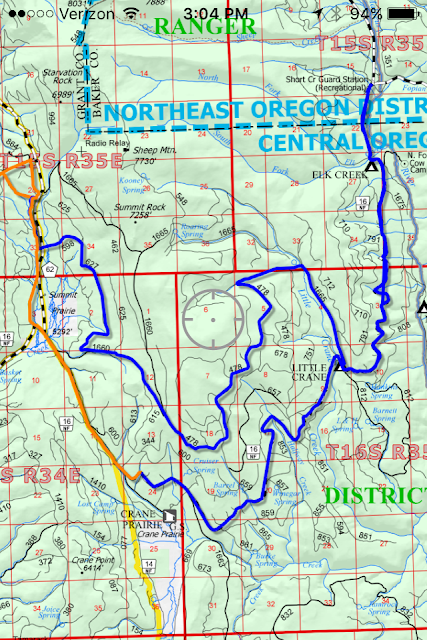
Groomed Trails - Summit Prairie 2/29/16

from glen johnston:

> Leap Day Grooming Report: Huddleston out to Short Creek.  Low temp of 18F and high 54F.  Great conditions and beautiful day out there.  Blue and orange route on the map (except for the orange triangle in the NW corner, not sure how that got there?)
>


click on image for larger version
you can save the larger version as a .png file to your computer
open and be able to zoom in for more detail.

Sunday, February 28, 2016

Groomed Trails - Summit Prairie thru Logan Valley 2/26/16

from glen johnston:

click on image for larger version
you can save the larger version as a .png file to your computer
open and be able to zoom in for more detail.

Monday, February 22, 2016

FR 1640 High Lake - Logan Valley 2/21/16

click on image for larger version
you can save the larger version as a .png file to your computer
open and be able to zoom in for more detail.


Location: FR 16 to 1640 jct

Road & Trail Conditions: FR 15 dry pavement, FR 16 mostly dry with packed ice in shaded areas. FR 1640 groomed 4 weeks ago.  numerous snomobile tracks & 1-6" new with elevation

Snow Conditions: 3-6' packed base depending on elevation. .5-4" powder on top, drier with elevation

Skis on & temperature: 7:45am 19°  mostly sunny  (JD 30°)

Skis off & temperature: 5:45pm 36°overcast with flurries (JD 43°)

Distance: 24 miles, elevation gain 3200 feet

Rating (1-10; 10 awesome): 10+

Comments: have made several trips on the 1640, this one the furthest.  great day, lovely snow.  skied to high lake rim & then tried the end of road trail head to get around toward strawberry peak - purple line above.  this is where the road heads right to high lake rim - trail is left - ski tracks:


break trail through alternating very deep snow & a few stretches of solid ice on steep slope.  saw this snow squall coming from bear valley & turned around:


incredible views in all directions:


 strawberry summit south face:


unbroken trail leading toward onion creek trail & strawberry


Saturday, February 20, 2016

Groomed Trails - Starr Ridge 2/19/16

click on image for larger version
you can save the larger version as a .png file to your computer
open and be able to zoom in for more detail.


Thursday, February 18, 2016

Dixie Butte - 2/18/16


click on image for larger version
you can save the larger version as a .png file to your computer
open and be able to zoom in for more detail.


Location: Hwy. 26 east of Prairie City to Dixie Summit Sno Park (permit required)

Road & Trail Conditions: Hwy 26 clear, plowed, wet, gravel at summit. FR 2610 1-2' compact base with .5-4" new sno depending on elevation

Snow Conditions: variable with elevation.  almost pristine at top, a little sticker at bottom, variable in between.

Skis on & temperature: 10:45am 36° mostly sunny (JD PC 47° )

Skis off & temperature: 2:45pm 36° moderate snow (JD PC 43° rain)

Distance: 8+ miles, 1.5 mile elevation - takes some legs & conditioning for the climb

Rating (1-10; 10 awesome): 10


Comments: almost spring skiing, still quite lovely.  another few degrees warmer or sunnier and the new snow would by sticky.  no travel on 2610 for several weeks.  without overnite snow, base would be slick ice.

spring rain in valley, snow on dixie


got to treeline; needed to head back.  great snow to summit. regular 20mph wind & 40mph gusts with moderate snow. a little intense.  past the treeline snow is deeper & drifts, still skiable.


snodrifts heading past treeline

almost perfect traction for elevation climb.  lovely downhill descent.  zippy in places, icy overhanging branches.  best downhill run of the season (not my strongest skill).


as long as the overnite temps get cold & with a few new .5" for several days in the forecast, could get back to great skiing conditions.

Wednesday, February 10, 2016

Groomed Trails - Starr Ridge to Parish Cabin to Seneca 2/10/16

click on image for larger version
you can save the larger version as a .png file to your computer
open and be able to zoom in for more detail.


Todays route in Green.
14 degrees at start and 48 at noon. Very icy at the start and too soft by noon.
Dave

(from kyle: whoever is closest to the thermostat - or knows where it is - could you please turn it down a notch or two.  thank you.)


click on image for larger version
you can save the larger version as a .png file to your computer
open and be able to zoom in for more detail.


Groomed Trails - Seneca 2/9/16

click on image for larger version
you can save the larger version as a .png file to your computer
open and be able to zoom in for more detail.


310 out of town west on 473 to 237, 3780 south to 31 west 37 to 195 then east on 37 to 3790 to 310, ps the 310 is plowed to dirt and mud

Friday, February 5, 2016

FR 1640 to High Lake - Logan Valley 2/4/16

click on image for larger version
you can save the larger version as a .png file to your computer
open and be able to zoom in for more detail.


Location:  FR 16 to 1640 jct

Road & Trail Conditions: FR 15 plowed awhile ago, deep truck ruts through snow, packed ice.  FR 16 regularly plowed, thin packed snow & ice.  1640 groomed a few days ago, a few snowmobile tracks, 1-4" new snow since.

Snow Conditions: 3-4' packed base depending on elevation. recent 2-4" almost powder on top. continual light to moderate flurries thru day

Skis on & temperature: 9:45am 28° cloudy  (JD 33°  cloudy )

Skis off & temperature: 5:45pm 34°

Distance: 19 miles,  elevation gain 3200 feet

Rating (1-10; 10 awesome): 10


Comments:  this is one incredible journey. starts with 3+ miles level along bear creek.  slow gradual climb to 1648 jct.  from there steeper & through lovely forest.  breaks out into open area toward top.  lovely. lovely.  turned around 1/2 mile from 1640 end; late in day & west headwind was pushing me backward in tracks.  took this as a sign. will head back on a clear day to get over ridge to high lake &
strawberry peak.

elevation profile:

click on image for larger version
you can save the larger version as a .png file to your computer
open and be able to zoom in for more detail.


downhill was super fun, controlled on forgiving powder & fast, 6mph easy to 1648 jct.

along ridge: temp at 20 windchill dropped to 10; hands got very cold without mitts.

past 1648 jct moves into burn area to the top.  very intense. am collecting photos from various burn areas to make into presentation.  frustrated that video won't operate more than 2 secs. in cold temps.

looking east toward logan valley
this trip had a big impact on me.  started as a conditioning run to take a shot at the top later; no sign at indian springs campground to signal turn around, just kept going.  partly the distance, partly the elevation, the views... and then, the burn area.  wind & blowing snow. black charred spars. snow & ice encrusted black charred branches.  it'll take awhile to find some words, maybe.

from conditioning run to awe inspiring pilgrimage

i love this place


Thursday, February 4, 2016

Groomed Trails - Summit Prairie 2/3/16

click on image for larger version
you can save the larger version as a .png file to your computer
open and be able to zoom in for more detail.


The Orange line is todays grooming, 2 3 16
Took cat 1 from Huddleston up 169, 101, 1649, 064, 1648, 1640 back to the 16. Walked cat on 16rd to Seneca, groomed the drag strip with cat 2 driven by Garrett.
Blue line is old groom from last week.
Cheers
Dave Hannibal

Monday, February 1, 2016

Dry Soda Lookout - Starr Ridge 1/31/16

click on image for larger version
you can save the larger version as a .png file to your computer
open and be able to zoom in for more detail.


Location: Hwy 395 to Starr Ridge Campground

Road & Trail Conditions: 395 patchy ice with gravel; FR 196 & 3925: groomed 2 weeks ago, a few snowmobile tracks since, 1-4" powder on top.  pretty darn good.

Snow Conditions: 2-3' packed base, crusty layer then powder on top, more with elevation

Skis on & temperature: 9:30am 19° mostly sunny, wind on ridges dropped temp quickly (JD 28° cloudy)

Skis off & temperature: 6pm 22°  (JD 32° )

Distance: 16 miles, 1 mile elevation climb

Rating (1-10; 10 awesome): 10


Comments: from the topo map the elevation is a little misleading, starting at 5200 at starr ridge, ending at 5400 at soda ash.  there is a lot of up & down in both directions.  here is an elevation profile from google earth:


 i love traveling along this ridge, alternately seeing canyon mtn, strawberry ridgeline to the north


 & bear valley to the south & west. 


the view from the lookout is extraordinary - worth the effort to get there.

FR 196 goes through several stages of the burn area; sometimes the southern border, sometimes right through the middle.  it is quite a journey to follow along the area, moving in the direction of the fire. most of the spur roads to the north are closed due to fire damage. from some of the viewpoints large sections of the burn area can be seen at once.  the camera could not capture the immensity of the area.


you can also approach from the other direction, FR 16 to 1620 up to 3925, same distance, another 500' elevation.